Sunday, December 31, 2006

NWR - Titusville - Trails & Drive Maps


The U.S. Fish and Wildlife Service - Merritt Island - National Wildlife Refuge has hundreds of acres of protected waters that are accessable by kayak. The following is a fishing map link.

Also available, on the U.S. Fish and Wildlife Merritt Island web site, are 17 trail and drive maps covering most of the refuge. Use this link to access the maps.

http://www.fws.gov/merrittisland/Maps-DrivesTrails/index.html

In addition, there is a no-motor zone within the refuge, that is great for kayak fishing. Use this link to access this web page.

http://www.fws.gov/merrittisland/MosquitoLagoon/index.html
Wednesday, December 20, 2006

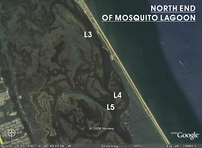
Mosquito Lagoon - North end - Launch Point L5

Launch Point L5 - The water access is located at the northwest corner of the parking lot through the trees. As with all launch locations within the park, mosquitos and noseeums can be a problem. Live bait can be caught from the shoreline with a cast net.

Mosquito Lagoon - North End - Launch Point L4

Launch Point L4 - The water access is through the treeline that boarders the lagoon. During times of the year when tempretures rise, mosquitos and nosseums (also know as biting midges) can be a problem. Always bring insect spray. Live bait can be caught from the shoreline with a cast net.

Thursday, December 14, 2006

Mosquito Lagoon - North End - Launch Point L3

Launch Point L3 - The water access is located just inside the main gate of the park. L3 has a concrete ramp. The ramp can be congested on weekends due to power boaters. The parking lot on the beach side has a restroom and shower. There are few bait and tackle stores on route to the park. If schools are present, mullet can be netted from shore.


Mosquito Lagoon - North End

There are three launch locations within the north end of the National Seashore. Launch Point L3 is just inside the main gate. Launch points L4 and L5 are water access points through breaks in the trees that line the shore. The first beach side parking lot, inside the main gate has restrooms and a shower.

Titusville Bait and Tackle Shops

There are many bait and tackle shops in Titusville. The map to the left shows the location of three shops that are in close approxcimaty to the Max Brewer Causeway.

Peacocks Pocket


Launch location L2 - Peacocks Pocket is located on the Intracoastal Waterway across from Titusville. Water access points vary along Peacock Pocket Road. This is a dirt road and conditions vary as to the amount of rain the area has received. Bait and tackle shops are located in Titusville. This fishing area boarders the JFK Space Center. All water locations within the boundary of the space center are off-limits to access and fishing. Fishing in the pocket can be great at times. There are many deep holes that hold fish. The water depth averages one to two feet.

Eddy Creek


L1 - Eddy Creek is very improved kayak launch location in the National Seashore. This launch location is a sand beach. There is ample vehicle parking and a rest room. There are no showers at this location in the park. There is a small fishing pier at this site. Live bait can be caught with a casting net all along the beach edge. The closest bait and tackle shops are located in Titusville, 14.5 miles from Eddy Cove. Fishing is excellent inside and outside of the cove. The cove botton is made up of sea grass and sand pockets. Water depth varies up to six to eight feet in places. With most of the cove averaging one to three feet.

Mosquito Lagoon


The Mosquito Lagoon is on most anglers list of go to places in Central Florida for large bull red fish. It is nestled between the Indian River and the Atlantic Ocean. It stretches from New Smyrna Beach in the north to Titusville in the south. There are many access points any where along the banks of the lagoon as long as one can find a place to park your vehicle and launch your kayak. The lagoon does not have a large tidal flow so water level remains fairly constant. Depending on lagoon location, alligators are present. During the warmer months, mosquitoes and noseeums can be a pest. The south end of the lagoon can be reached via Titusville by crossing the Max Brewer Causeway (highway 402) to Canaveral National Seashore and Playlinda Beach. There is a $5.00 user fee to enter the National Seashore. It is approximately 14.5 miles from Titusville to Playlinda beach.

Sunday, December 10, 2006

Sebastian Inlet State Park - South Side

Launch Point L6 - Located at the south end of the park is a water access point located along A1A. There is a visible stop sign located on the right side of the road. The sand road will lead to a small area for four to five vehicles to park. The water access is through an opening in the mangroves. Using this launch point instead of L5, allows the paddler not to have to compete with boats while using the L5 ramp. Fishing the flats and mangrove edges can be very productive.

Sebastian Inlet State Park

Sebastian Inlet is one of the most notable fishing locations in Central Florida. The park is located approximately 18 miles south of Melbourne Beach, FL along A1A. The park is divided into two halves caused by the inlet. There is a $3.00 park user fee for a vehicle with one person and a $5.00 fee if there are two or more in the vehicle. Launch Point L4 - This is a water access point located on a small sandy beach lagoon inside the park by the main the parking lot. This point can give access to the ocean when the tidal flow has stopped. All other times, the access to the ocean, may be impassable. Boat traffic through the inlet can be very heavy. Launch Point L5 - This is a concrete boat ramp located in the south side of the park. The fishing along the north and south sides of the park, along the edges of the mangroves, for red fish, snook and trout can be very productive. One should pay strict attention to the tides as the water can be less than six inches deep in may areas at low tide. There are some oyster beds in this area with sea grass and sand being the predominate bottom cover.

Longs Point Campground and State Marina Launch Points


Launch Point L1 - This is a water access located at the entrance to the campground. The water access is on the left side of the road with parkng for about 6 - 8 vehicles. There is an opening in the mangroves to launch.
Launch Point L2 - This is a concrete boat ramp located in the campground. There is a $3.15 launch fee. The campground is open 24-hours a day. There is a drop box for your launch fee if you arrive before the parks opens. The park has showers and restrooms. Launch Point L3 - This is a concrete boat ramp located in the Sebastian Inlet State Marina. The marina opens each day at 8:00 AM. There is a $3.00 per kayak launch fee. Kayaks can be rented at this location.

SEBASTIAN INLET KAYAK LAUNCH SITES


Sebastian Inlet is one of my favorite kayak fishing locations. The inlet launch points are located about 18 miles south of Melbourne Beach, Florida along highway A1A. There are three boat ramps and three water access points for launching your kayak. Two of the launch points are located at Longs Point Brevard County Camp Ground. One is located at the Sebastian Inlet State Marina. Two are located in the Sebastian Inlet State park and last being a water access just south the Park's south entrance. You can get bait and tackle in the north side of the state park as well as Long's Point and Whitey's Bait and Tackle just north of the north side park entrance on A1A.

Wednesday, November 29, 2006

Bait & Tackle Stop List


The bait and tackle shops and marina list may not include all retail location in Brevard County but it includes most of them. Many of these outfitters do not open before 6:00 AM so plan your bait and tackle needs accordingly.

Ramp Road Boat & Kayak Launch From The South


From I-95 take Wickham Road (Highway 509) east to Pineda Causeway (Highway 404. Turn left onto Highway 404 and travle to A1A. Turn left onto A1A and go North to 5th street. At 5th take a left and go two blocks to Brevard Ave. South and turn left. Ramp Road is the first road to the right. Boat and kayak ramps are at the end of the road. The kayak ramp is adjacent to the restroom building. Parking is free. The Ramp Road launch ramp is the closest launch ramp to the 1000 Islands fishing grounds.

Ramp Road Boat & Kayak Ramp From The North


From I-95 take State road 520 and go East to Cocoa Beach. Turn right on A1A and go South to 5th street. At 5th take a right and go one block and turn left. Ramp Road is the first road to the right. Boat and kayak ramps are at the end of the road. The kayak ramp is adjacent to the restroom building. Parking is free. Ramp Road is the closest launch ramp to the 1000 Islands fishing grounds. See bait and tackle store list.

Tuesday, November 28, 2006

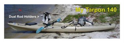
My Fishing Kayak - Tarpon 140


After doing a lot research on the internet, I decided that the Wilderness Systems brand of sit-on-top fishing kayaks was going to be my selection. All the reviews that I read told me that this was one of the best. All i had to do was to pick a boat. I especially liked the way the cockpit was laid out on the Tarpon series and the center rod holder. After making this choice, I looked for a Melbourne kayak rental location. I was in luck. Extreme Sports in Indian Harbor Beach sold and rented Wilderness System Kayaks.

EXTREME SPORTS
294 E EAU GALLIE BOULEVARD
INDIAN HARBOR BEACH, FL 32937
Phone: 321-779-4228

I was able to rent a Tarpon 140 sit-on-top kayak. I planned a test paddle in the 1,000 Islands area of Cocoa Beach. This was a great place to try out a kayak. The launch ramp is located at the end of Ramp Road. My Tarpon 140 has a dual rod holder system by Scotty. I get all my kayak accessories from Hook 1 - www.kayakfishinggear.com They carry a full line of Scotty kayak accessories.


The Yak Fisher